|
The
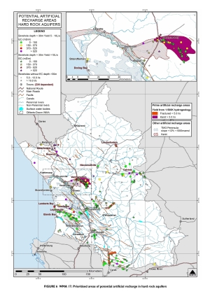
maps shown here provide a rough estimate of South Africa’s
the artificial recharge potential. These estimates are based on
hydrogeological factors only, and not on the availability of water for
recharge. The hydrogeological factors used are:
- Aquifer type and
hydraulic conductivity
- Potential
aquifer storage
A
full
description of the method use to develop the first map (AR
Potential Areas) is captured in the report Potential
Artificial Recharge Areas in South Africa.
This map has been reproduced for each WMA in Appendix
1.
The
method
use to develop the remaining maps are described in Artificial
Recharge Strategy under
section B.4.4. Regional scale
artificial recharge potential on page
59. The
estimated Artificial Recharge Potential per WMA is given in Appendix
1 of the report.
Click
on the image below to enlarge. Then press
Crtl+
to
enlarge
more in your browser view
|